ENGLISH TEXT BELOW…
Version française:
Randonnées dans les provinces belges des Flandres occidentales et du Hainaut.
Lundi 29 juin 2015 : 150,32 km, moyenne de 22,35km/h.
Itinéraire : Staden (piste cyclable à partir de Kappelleriestraat) – Langemark – Poelkapelle – Sint-Juliaan – Sint-Jan – Potyze – Zillebeke – Kemmel – Kemmelberg (pavés, 162m) – Nieuwkerke – Ploegsteert (Province de Hainaut) – piste cyclable près de Warneton, Bas-Warneton, Comines-Warneton, puis piste le long du Lys – Wervik – Menen – Wevelgem – Bissegem – Kortrijk/Courtai-centre – Zwevegem – Otegem – Tiegem – Tiegemberg (76m) – Anzegem – N382 nord-ouest passant près de Waregem, Ingelmunster, Izegem, Rumbeke, Roeselare – Staden.
Route par Garmin GPS : https://connect.garmin.com/modern/activity/821167805
Des textes explicatifs ci-dessous (en italique) de différents sites, villages et villes ont été glanées de l’Internet, en particulier Wikipedia.
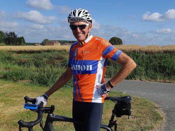
Lundi 29/06/2015 : Je n’ai pas bien dormi la première nuit à notre hôtel à De Panne ; il était probablement dû au repas copieux et au bon vin que nous avons pris dans un des nombreux bons restaurants que l’on trouve dans la ville. J’ai dormi de 22h30 à 2h30 et suis alors resté éveillé jusqu’au réveille-matin à 6h00.
Après une douche et un bon petit déjeuner, je pars pour Staden en voiture où je commence ma randonnée cycliste dans la partie du sud de la province.
Je laisse Staden derrière moi à environ 8h15, je trouve une piste cyclable qui me dirige à Langemark, où je dois faire un petit demi-tour pour Poelkapelle.
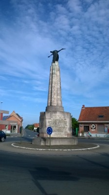 Photo: Le Monument de Mont Guynemer.
POELKAPELLE – Site 1914-18, Le Monument de Mont Guynemer (http://www.histoiredumonde.net/Georges-Marie-Guynemer.html)
Georges Guynemer, né le 24 décembre 1894 à Paris, mort le 11 septembre 1917 à Poelkapelle (Belgique), est le pilote de guerre français le plus renommé de la Première Guerre mondiale, bien qu’il ne soit pas l’as des as.
Capitaine dans l’aviation française, il remporta 53 victoires homologuées et plus une trentaine de victoires probables en combat aérien. Volant sur différents types de Morane-Saulnier, de Nieuport et de SPAD (VII, XII canon, mais jamais sur le XIII contrairement à ce qu’affirment plusieurs sources), il connut succès et défaites (il fut abattu sept fois), affecté durant toute sa carrière à l’Escadrille 3, dite “Escadrille des Cigognes”, l’unité de chasse la plus victorieuse des ailes françaises en 1914-1918.
Après avoir pris quelques photos, je repars pour ma prochaine destination de Zillebeke, passant sur le chemin par les villages de Sint-Juliaan, Sint-Jan et Potijze.
 Photo: L’étang de Zillebeke.
ZILLEBEKE – L’étang de Zillebeke (http://www.toerisme-ieper.be/fr/page/234-249/etangs.html) est 26 ha et il se faisait au 14e siècle par l’endiguement du Vijverbeek. Le domaine a comme première fonction la production d’eau. Il y a la possibilité de se promener ou de faire du vélo autour de l’étang.
Avec l’aide d’un gentil habitant de Zillebeke, je trouve rapidement le lac où je fais quelques photos et un tour du lac. Mon prochain but n’est pas loin à Kemmel et le Kemmelberg. L’altitude dans la région varie entre 5 à 30 mètres; le Kemmelberg est un défi avec une montée longue de 750m entre 14 et 23% et avec une route de pavés.
 Photos: Kemmelberg dans la distance.
KEMMELBERG (sommet 162m) – Le mont Kemmel (Kemmelberg) est le point culminant de la province de Flandre-Occidentale, en Belgique. Son altitude est de 162 m. Le sommet est matérialisé par une borne géodésique de l’Institut géographique militaire, mise en place en octobre 1951, à proximité du domaine militaire. Il se situe sur la commune de Heuvelland, à 1,5 km du village de Kemmel.
Dans le monde du sport, le mont Kemmel est connu en tant que juge de paix de la course cycliste Gand-Wevelgem, courue en avril. Il se situe également sur le parcours d’autres courses professionnelles comme les Quatre jours de Dunkerque, les Trois jours de La Panne, le Circuit franco-belge ou les Trois jours de Flandre-Occidentale. Il fut emprunté durant les Championnats du monde de cyclisme sur route de 1950, qui couronnèrent le Belge Briek Schotte. Les pavés et la forte pente de la route (avec un maximum à 23 %) font l’intérêt du lieu, mais suscitent également des critiques du fait de la dangerosité du passage. Ainsi en 2003, le peloton des Trois jours de La Panne refusa de passer par le mont Kemmel.
D’ici je me dirige vers le sud vers Lindenhoek, Nieuwkerke (où une gentille dame me pointe dans la bonne direction), Le Romarin et puis Ploegsteert. Dans cette région de la Belgique, sont nombreuses des cimetières datant de la Grande Guerre.
 Photo: L’église de Ploegsteert.
PLOEGSTEERT (Enclave, confins du Hainaut) – Ploegsteert (en picard “Plostèr” ou “Prustèr”) est une section de la commune belge de Comines-Warneton, située en Région wallonne, dans la province de Hainaut. C’était une commune à part entière avant la fusion des communes de 1977.
Ploegsteert est la localité la plus occidentale de la Région wallonne.
Mon tour continue par Gheer, Warneton et Comines. À Comines je continue sur la piste cyclable qui longe la Lys en compagnie de douzaines d’autres cyclistes.
Près de Wevelgem je suis en train de consulter la carte quand un cycliste propose d’être mon guide jusqu’à Zwevegem, sa ville natale. J’accepte avec plaisir et il me guide à travers le centre de la belle ville de Kortrijk/Courtrai où je prends quelques photos de la ville.
 Photo: L’église à Zwevegem.
ZWEVEGEM (Collines du Courtraisis) – Zwevegem est une localité et une commune néerlandophone de Belgique située en région flamande dans la province de Flandre-Occidentale. La compagnie Bekaert y fut fondée par le baron Leon Leander Bekaert.
Outre Zwevegem, la commune comprend aussi les sections de commune rurales de Heestert, Moen, Otegem et Sint-Denijs. La localité de Zwevegem se trouve au nord de la commune, dans la périphérie urbaine de Courtrai. Les quatre autres villages se trouvent au sud de la commune.
À Zwevegem nous nous disons “au revoir” et je continue ma route vers le Tiegemberg, passant par Otegem et Tiegem. Tiegemberg est une autre importante côte de la région; ma seconde de la journée! Les vues d’ici sont magnifiques.
 Photo: Le moulin au Tiegemberg.
TIEGEMBERG (Vue – Moulin) – Le Tiegemberg est situé en Province de Flandre-Occidentale et appartient aux Ardennes flamandes. À partir de Tiegem, la montée de Tiegemberg est de 0,75 kilomètres de longue avec 42 m de dénivelé positive. Le pourcentage moyen est ainsi 5.6 %. La pente maximum est 9 %.
Mes buts pour ce dernier lundi de juin 2015 sont atteints et je repars à Staden par la N382 passant près ou à travers Anzegem, Waregem, Ingelmunster, Izegem, Rumbeke et Roeselare.
C’était une belle randonnée de 150km à une vitesse moyenne de 22,35km/h ; pas très rapide vu que c’est “le plat pays” 🙂
_________________________
English version:
Circuits in the Belgian provinces of West Flanders and Hainaut.
Monday 29 juin 2015 : 150,32 km, average speed 22,35km/h.
Itinerary: Staden (cyclepath from Kappelleriestraat) – Langemark – Poelkapelle – Sint-Juliaan – Sint-Jan – Potyze – Zillebeke – Kemmel – Kemmelberg (cobblestones, alt. 162m) – Nieuwkerke – Ploegsteert (Provinceof Hainaut) – cyclepath near Warneton, Bas-Warneton,
Comines-Warneton, cyclleway along the River Lys – Wervik – Menen – Wevelgem –
Bissegem – Kortrijk/Courtai-centre – Zwevegem – Otegem – Tiegem – Tiegemberg (76m) – Anzegem – N382 north-west passing near to Waregem, Ingelmunster, Izegem, Rumbeke, Roeselare – Staden.
Garmin GPS route: https://connect.garmin.com/modern/activity/821167805
Parts of the explanatory texts below (in italics) giving details of different sites, villages and towns have been gleaned from the internet, in particular Wikipedia.
Monday 29/06/2015: I didn’t sleep well during the first night at our hotel in De Panne; it was probably due to the heavy intake of food and wine in one of the many good restaurants to be found in the town. So I slept from about 22h30 to 2h30 in the morning and then remained awake until the alarm clock at 6h00.
After a shower and a good breakfast, I drove the car to Staden where I started my cycling trip in the southern part of the province.
Leaving Staden at around 8h15, I quickly found a cyclepath which led me to Langemark, however I had to double back on the main road to my first stop at Poelkapelle.
POELKAPELLE – 1914-18 Mont Guynemer Monument (http://www.greatwar.co.uk/ypres-salient/memorial-guynemer.htm).
The sculpture of the “Guynemer Stork” on the memorial, with its wings down as in the stork emblem of Escadrille N.3, is flying in a north-easterly direction. Captain Guynemer was last seen by Sub-Lieutenant Bozon-Verduraz flying in this direction before he went missing.
After my photoshoot, I ride on to my next destination of Zillebeke, passing on the way through the villages of Sint-Juliaan, Sint-Jan and Potijze.
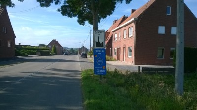 Photo: Coming into the village of Zillebeke.
ZILLEBEKE LAKE (http://www.ww1battlefields.co.uk/flanders/zillebeke.html) – The village of Zillebeke is located about one and a half miles south-east of Ypres, and there is a lake of the same name nearby. There are many sites of interest to be seen, both in the village and also in the surrounding area – so this page covers locations for some distances in all directions around the village. To reach the village, follow the N8 from Ypres (towards Hooge and Menen), and go right at the roundabout where it joins the N345 and N37, following the sign for Zillebeke. (This roundabout is on the location of what was the infamous ‘Hellfire Corner’).
Following this route, on the northern outskirts of the village are two cemeteries. The first is Perth Cemetery (China Wall), which is located on the left hand side of the road.The village of Zillebeke is located about one and a half miles south-east of Ypres, and there is a lake of the same name nearby. There are many sites of interest to be seen, both in the village and also in the surrounding area – so this page covers locations for some distances in all directions around the village. To reach the village, follow the N8 from Ypres (towards Hooge and Menen), and go right at the roundabout where it joins the N345 and N37, following the sign for Zillebeke. (This roundabout is on the location of what was the infamous ‘Hellfire Corner’).
With the help from a friendly inhabitant, I quickly find the lake. A few photos and a tour of the lake and then onwards I ride to Kemmel and the Kemmelberg. Considering that the altitude in the region is around 15 to 25 metres above sea level, the Kemmelberg is a challenge in more ways than one: cobblestone road, steep climb to 162m with uphill percentages between 14 and 23%.

 Photos: 1. At the bottom of the hill. 2. The last section of the cobbled hill with a gradient of 23%.
KEMMELBERG (altitude 162m) – Where West Flanders presses up against the border with France the land has buckled into a series of rounded hills, and within them lies the Kemmelberg (http://www.cyclingweekly.co.uk/news/iconic-places-the-kemmelberg-2374).
The Kemmelberg, also known as Kemmel Hill or Mont Kemmel, is a 162m high hill near Kemmel in the municipality of Heuvelland in West Flanders, Belgium.
In the world of the sport, the Kemmelberg is part of the Ghent-Wevelgem cycle race, run in April. It is also ridden in other races, such as the “Four Days of Dunkirk”, the “Three days of De Panne” and the “Three Days of West Flanders”.
The cobblestones and the strong incline (between 14 and 23%) make it interesting to ride, but does cause criticism because of dangerousness of the passage.
During World War I, it was an important battle site. It was taken on 25 April 1918 by the Germans (during the Battle of the Lys). Several streets (Kemmel-Privatweg in Magdeburg) and barracks (Kemmelkaserne in Murnau, 1939-1994) in Germany were named after this event. Friedrich Bertram Sixt von Armin and Prince Franz of Bavaria were commanders, but Karl Höfer was celebrated as hero of Kemmelberg. It was recaptured (during the Battle of the Peaks of Flanders) in late September 1918.
From here I ride south to Lindenhoek, Nieuwkerke (where a kind lady points me in the right direction), Le Romarin and on into Ploegsteert. In this region of Belgium, there are numerous British and Commonwealth graves from the Great War.

PLOEGSTEERT is an enclave, being part of the Province of Hainaut which is bordered by the Province of West Flanders and France.
The name of this small village, and of the nearby wood, is actually Ploegsteert, but to those who served here during the Great War it became known as “Plugstreet”. The village is at the very south of the area associated with Ypres; in fact it is not regarded as part of the ‘Ypres Salient’ by many. It is only about two miles north of Armenitières, close to the French border and eight miles south of Ypres (http://www.ww1battlefields.co.uk/flanders/plugstreet.html).
My ride continues through Gheer, Warneton and Comines. At Comines I continue on the cyclepath alongside the River Lys in the company of dozens of other cyclists.
Near Wevelgem I stop to look at my map and an elderly gentleman proposes to be my guide to Zwevegem, his hometown. He kindly leads me through the centre of the ancient and beautiful town of Kortrijk/Courtrai where I take a few photos of the town.
ZWEVEGEM (Hills of the Courtraisis) – Zwevegem is a municipality located in the Belgian province of West Flanders. The municipality comprises the towns of Heestert, Moen, Otegem, Sint-Denijs and Zwevegem.
At Zwevegem we say our goodbyes and I continue to Tiegemberg, passing through Otegem and Tiegem. Tiegemberg is another hill-climb; my second of the day! The views from here are magnificent.

TIEGEMBERG (Viewpoint and Windmill) – The Tiegemberg is situated in West Flanders and belongs to the Flemish Ardennes. Starting from Tiegem, the Tiegemberg ascent is 0.75 km long. Over this distance, you climb 42 meters to an altitude of 76m. The average percentage thus is 5.6 %. The maximum slope is 9 %.
My goals for the day are achieved and I return to Staden by the national road N382 passing near or through Anzegem, Waregem, Ingelmunster, Izegem, Rumbeke and Roeselare.
It was a good day’s ride of 150km at an average speed of 22,35km/h; not very fast considering the flatness of the countryside 🙂
